


Maps
Artist / Author / Cartographer:
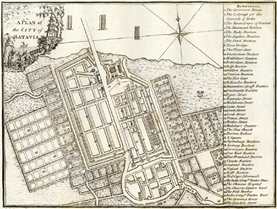
John Andrews & Andrew Dury
Title:
A plan of the City of Batavia
Date:
1771
Medium:
copper engraving
Size:
17.3 x 23 cms.
Description:
An eighteenth century city plan of the city of Batavia which was on the north coast of Java in the East Indies. This was the capital city for Dutch colonial interests in the Far East. In 1949 Batavia was renamed Jakarta which is today the capital city of Indonesia.
The English mapmakers Andrews and Dury were working in London in the second half of the eighteenth century. This city plan of Batavia in Java appeared in their joint publication, …Plans of Capital Cities of Europe, Asia, Africa and America 1771.
References:
Tooleys Dictionary of Mapmakers Revised edition 1999 p.32
…Plans of Capital Cities of Europe, Asia, Africa and America 1771 Andrews and Dury
Item Code:
MA5443
attachment:
