


Maps
Artist / Author / Cartographer:
Title:
Date:
Medium:
Size:
Description:
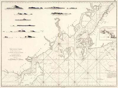
Nouvelle Carte des Mers Comrises entre Le Detroit de Banca et Po. Timon, avec la partie Orientale du Detroit de Malac.
This chart only appeared in the second and enlarged edition of Mannevillette's Le Neptune Oriental
Engraved by Guillaume-Nicolas DelaHaye {1727 - 1802}
A late 18th century nautical chart of Singapore Island and neighbouring islands and countries. Upper left of the chart is the east coast of Sumatra. Upper right is the peninsula of Malaysia. Singapore Island appears at the tip of the peninsula as "I. de Jatana ou de Saincapour". The northern part of the island is called "Det. de Salete Baro". Det. is the abbreviation of Detroit or Straits. Many rhumb lines and soundings appear on the chart. Embellished with perspective views.
Guillaume-Nicolas DelaHaye came from a family of fine engravers who worked for many of the leading French cartographers of their day. Guillaume worked with D'Anville, De Vaugondy, Dezauche and others in the second half of the eighteenth century. He also worked with the Depot de la Marine from 1752 - 1785 where he worked with Nicolas Bellin and other leading hydrographers producing among the finest nautical charts of the time.
References:
Item Code:
attachment:
