


Artist / Author / Cartographer:
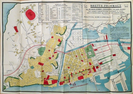
Japanese Mapmaker
Title:
Yokohama
Date:
c.1920
Medium:
woodblock in colours
Size:
32.3 x 46.3 cm
Description:
An attractive map of the port of Yokohama, Japan at the beginning of the twentieth century.
A city plan giving street names, places of interest etc and numbering each block of land. Inset shows the railway system in the vicinity of Yokohama. A very good copy of an unusual piece of travel/advertising ephemera. Originally a folded map which folds into brown paper printed covers. This map was likely given to visitors to Yokohama as it shows the main places of interest, hotels, consulates, shipping offices and banks. Serving as a promotional tool for Brett's Pharmacy "The Largest Foreign-Staffed Dispensary in Japan" the details of Brett's are printed in the upper left corner and on the map's paper covers.
References:
Item Code:
MA6874
attachment:
