


Artist / Author / Cartographer:
Title:
Date:
Medium:
Size:
Description:
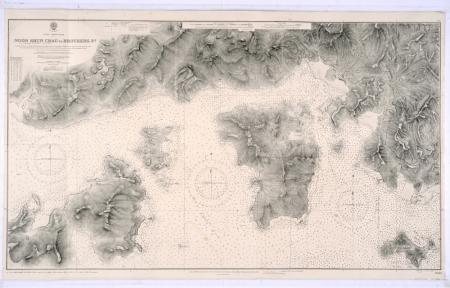
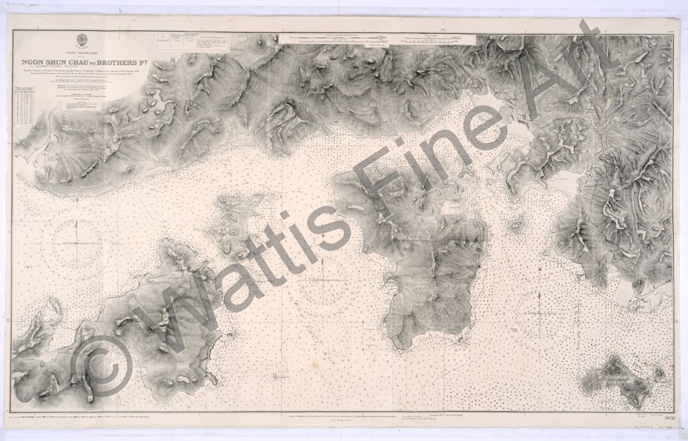
Chart No. 3632 - China - South Coast - Ngon Shun Chau, or Stonecutters Island, to Brothers Point. Rambler Channel to Brothers Point including Kap Shui Mun by Commander C.F. Munro & the Officers of HMS Rambler, 1906. The remainder from surveys by Captain W. Usborne Moore, R.N. 1893, and by Captain Morris H. Smythe, R.N., 1902. With corrections from Hong Kong Harbour Department surveys to 1933.
New Edition 31st December 1915. Large corrections to 17th May 1935. Small corrections to 1949. Soudings in fathoms. Scale 1:12,150.
A nautical chart of north west Hong Kong Harbour 1949.
A detailed Admiralty chart of part of the waters west of Hong Kong Harbour and north of Lantau. Including Ma Wan, the village of TingKau, Kap Shui Mun (Cap Sing Mun), Tsing Yi, Tsuen Wan, Gin Drinkers Bay, Kwai Chung, Cheung Sha Wan and Stonecutters Island.
The chart was first published in 1908, based on the surveys of Commander C.E. Monro of H.M.S. Rambler, 1906, Captain W. Usborne Moore, R.N., 1893, and Captain Morris H. Smyth, 1902. It was updated with corrections from the Hong Kong Harbour Department surveys to 1933, and further updated to 1949.
The map features ubiquitous soundings and extremely detailed topography.
Discovery Bay and Disney Land would be built on the east coast of Lantau just south west of the island of Tang Lung Chan. Stonecutters Island is shown in the lower right of the map. After reclamation, the island has become part of Kowloon.
References:
Item Code:
attachment:
