


Artist / Author / Cartographer:
Title:
Date:
Medium:
Size:
Description:
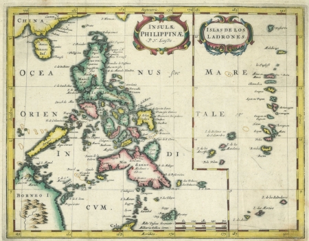
Insulae Philippinae P.N. Sanson; Islas de Los Ladrones.
A charming early map of the Philippine Islands. At the top of the map Canton and Amacao appear. Luzon is boldly represented with some detail after Legaspi had arrived in 1572 in Manila. The mythical isle of San Juan appears off the north east coast of Mindanao. It was beautifully engraved by Abraham Peyrounin for Nicolas Sanson and was published in Paris in the mid seventeenth century. Sanson is regarded as the father of French cartography.
An unusual variant state of the Sanson map of 1652 which was originally engraved by A. Peyrouin in Paris and signed lower right in the plate. This map has no engravers name. Later states of the map were engraved by A. de Winter in 1683 and also signed in the plate lower right. These were known as the pirated copies.
Nicolas Sanson was born in Abbeville where as a young man he studied history, particularly of the ancient world, and it is said that he turned to cartography only as a means of illustrating his historical works. For this purpose he prepared a number of beautifully drawn maps, one of which, after he moved to Paris, came to the attention of Louis X111. In due course the King appointed him 'Geographe Ordinaire du Roi', one of his duties being to tutor the King in geography.
Not in Quirino.
References:
Item Code:
attachment:
