


Maps
Artist / Author / Cartographer:
Title:
Date:
Medium:
Size:
Description:
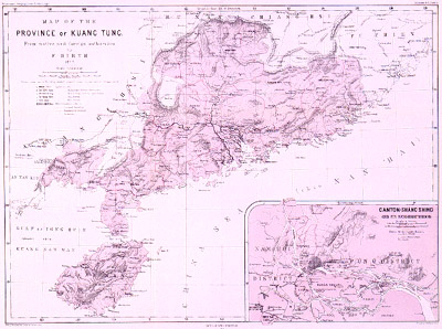
Canton - Map of the Province of Kuang Tung (Guangdong) From native and foreign authorities by F. Hirth 1872. Scale 1: 2,600,000. Chinese names are in the Peking dialect, nautical names as put down on foreign charts. The map was published by Gotha Justus Perthes 1873.
A detailed German map of Guangdong province in the second half of the nineteenth century. The map also shows Hainan Island in some detail. Rivers and mountains are shown. Inset lower right with a map of Canton (Shang Shing) and its neighbourhood. Names in the Canton dialect.
The accomplished German mapmaker Augustus Petermann was a noted draughtsman who became Geographer and engraver to Queen Victoria. At the age of 17 he joined Heinrich Berghaus's school of engraving. In 1845 he moved to Edinburgh to work on A.K. Johnston's The Physical Atlas. In 1847 he started working in London by himself at Charing Cross. He was active with the Royal Geographical Society and would be awarded the RGS Founders Medal in 1868. In 1854 he returned to Gotha, Germany to work with Bernhardt Perthes at the Justus Perthes publishing company. Under his influence the company would grow into a world famous geographical institute.
Friedrich Hirth was born in Germany in 1827. From 1870 - 1897 he was in the Chinese Customs Service. He was president of the North China Branch of the Royal Asiatic Society for the years 1886-87. In 1902 he became the first Professor of Chinese at Columbia University.
References:
Item Code:
attachment:
