


Maps
Artist / Author / Cartographer:
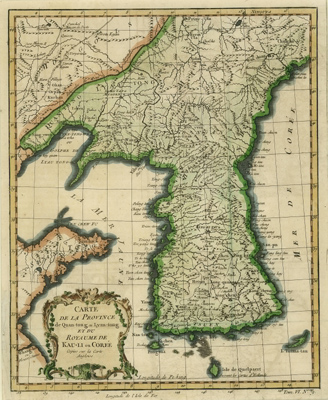
Title:
Date:
Medium:
Size:
Description:
An early European map of Korea. Although the map's title states this is copied from an English map it is based on the Jesuit map published by D'Anville and Du Halde in Paris in 1735, which in turn was based on information from Chinese sources.
The French cartographer Nicolas Bellin worked for over fifty years at the French Hydrographic Service where he was appointed the first chief hydrographic engineer of the “Depot des cartes, plans et journaux du Ministere de la Marine”. While working there he was commissioned to carry out major surveys of all the known coasts of the world. This resulted in the production of a large number of sea charts of the highest quality which appeared in many editions with varying numbers of charts. He was appointed ‘Hydrographer to the King’ and was a member of the Royal Society in London. Among the books and atlases that contained Bellin’s maps of China and East Asia were Abbe Prevost’s Histoire Generale des Voyages 1746 and Le Neptune Francais 1753.
References:
Item Code:
attachment:
