


Artist / Author / Cartographer:
Title:
Date:
Medium:
Size:
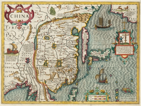
Description:
One of the most elegant early maps of China beautifully engraved by the Dutch engraver and mapmaker, Jodocus Hondius. It was included in the Mercator Hondius atlas from 1606. Korea, as an island, and Japan are after the Ortelius map of Japan of 1595. North America appears in the top right corner. The map is engraved with ships, a sea monster and a four- wheeled cart with a sail. A number of the descriptions and details are based on the accounts of one Portuguese and two Spanish missionaries who visited the interior of China in the sixteenth century. The Great Wall is depicted and Korea appears as a slender flint-shaped island. One of the cartouche contains a scene of crucifixion that relates to the Christian missionaries and converts who became martyrs in Nagasaki in 1597. This map includes an early outline of the Island of Formosa (I.Fermosa) off the coast of China.
In 1604 Hondius bought the copper plates for the Mercator Atlas from the Mercator family. He continued to work on the atlas and produced 37 more maps which he published together with the originals in his World Atlas of 1606. The maps were beautifully engraved and many of them were more up to date than those of his rival Abraham Ortelius which appeared in the popular Theatrum Orbis Terrarum. The Mercator Hondius Atlas was a great success and was to be published in a number of different languages.
Framed
References
Atlantes Neerlanici Koeman p.156
Collecting Antique Maps Jonathan Potter p.123
Antique Maps Moreland and Bannister p.102
References:
Item Code:
attachment:
