


Artist / Author / Cartographer:
Norie, John William
Title:
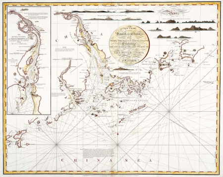
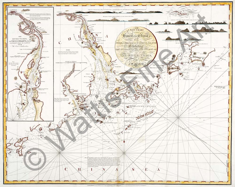
A New Chart of the Coast of China
Date:
1840
Medium:
copper engraving, later colour
Size:
62.5 x 77 cm
Description:
A New Chart of the Coast of China from Pedra Branca to St. John's Island Exhibiting the Entrances to, and Course of The River Tigris. Drawn from the latest surveys by J. W. Norie. Stephenson Engraver. A New Edition 1840.
A New Edition. London. Published as the Act directs April 13th 1840 by J.W. Norie & Co. at the Navigation Warehouse & Naval Academy No. 157, Leadenhall Street
A magnificent and extremely rare chart of the Pearl River Delta published in 1840. There is an inset detail upper left of The River Tigris, or Choo-Keang, from Lankeet Isle to Canton From the best Authorities. Upper right there are five lines of Views, including the Boca Tigris and the Ladrone and Lema Islands. The chart also contains numerous Notes (on Whampoa, Canton, the Ladrone islands etc.); one of these notes states: "The Cap-sing-Moon Passage is safe, but of irregular depth, from 12 to 25 fathoms, the bottom, in some places, is gravel & stones."
Hong Kong Island is shown as “Heong Kong” with Tai Tam Bay identified as “Tytam Bay”. The outline of the island follows the survey of Hong Kong by Lieutenants Daniel Ross and Philip Maughan of the Bombay Marine, published in 1810 in their chart of the Passages leading to Macao Roads. Whilst inaccurate in a number of details, the Ross map was a great improvement on the first depiction of Hong Kong (named “Fan Chin Chow” and not clearly shown as an island) by Alexander Dalrymple is his seminal A Chart of Part of the Coast of China ... of 1771, and also on the subsequent A Chart of the China Sea from the Island of Sanciam To Pedra Branca with the Course of the River Tigris From Canton to Macao … published by Sayer & Bennett / Laurie & Whittle “from a Portuguese draught communicated by Captain [George] Hayter” (and subsequently updated by Captains Joseph Huddart and John Pascal Larkins) of the East India Company that show Hong Kong as two islands. Norie’s chart of 1840 pre-dates by only a year the first truly accurate survey of Hong Kong by Captain Edward Belcher in 1841.
Norie’s A New Chart of the Coast of China … is an updated version of two earlier sea charts. The first was published c1804 by William Heather (1764-1812), and the second by Steel & Co. in 1810. Heather, an engraver and chart publisher, worked for John Hamilton Moore, an established publisher and teacher of navigation in London. In 1793 Heather opened his own business “at the sign of The Little Midshipman, No. 157 Leadenhall Street”, later called the “Navigation Warehouse”. His earliest charts were produced for the British coasting trade, followed by charts for the American trade, but by 1805 Heather had added 23 charts covering the route to Asia and was in a position to compete with the firm of Laurie & Whittle whose East India Pilot had become the leading English guide to eastern seas since its original publication (by Sayer & Bennett) in 1778.
William Heather died in 1812 and the business was acquired by one of his trustees, John William Norie (1772-1843), in partnership with George Wilson (1753-1831). Norie became a prolific hydrographer, chart publisher and author of navigation textbooks and pilots (sailing directions). The 1817 catalogue of “J.W. Norie & Co. (Successors to the late William Heather) Chartsellers to the Admiralty, and the Honourable East India Company” lists 143 charts, of which 27 cover “Eastern Navigation. Cape of Good Hope, Isle of France, Indian Ocean, Bay of Bengal, East Indies, China, New Holland &c.” These include (as no. 139) The Coast of China from Pedra Blanca (sic) to St. John's Island, containing all the Entrances to Canton, priced at 7s 6d.
In 1819, J.W. Norie & Co. acquired the “case fixtures, stock in trade and copper plates” of Steel & Goddard, a firm originally founded by David Steel in the 1780s, inherited by his son David in 1799 and, in 1803, taken over by the latter’s widow Penelope. Steel's New Chart of the Coast of China from St. John's Island to Pedra Branca, Shewing the Entrances to, and course of the River Tigris to Canton was published “by Steel & Co. at their Navigation Warehouse no. 70 Cornhill, October 1st 1810.” This chart must pre-date the publication of the Ross survey as Hong Kong is still shown as two separate islands.
Given the change in title from the 1817 catalogue, it appears that A New Chart of the Coast of China … was published after Norie’s acquisition of Steel’s plates and combined the best of both the Heather and the Steel charts, resulting in a magnificent, late example of the William Heather / J.W. Norie house style. The title is set in decorative florid scripts within a simple round frame, complemented by extravagant scrolling (notably the “Views”), the River Tigris inset, views, a wealth of hydrographic detail, rhumb lines and a small fleur-de-lys indicating true north. By the 1830s the Royal Navy was using functional Admiralty charts with a modern, undecorated look but, although Admiralty charts were offered for sale to the public from 1821, the “blueback’” charts available from private publishers continued to be preferred by most merchant shipmasters because of their familiar (albeit elaborate) style, convenient scales, and use of inset plans showing ports and narrow passages.
William Heather first employed an outside engraver, John Stephenson of Wilmot Square, Bethnal Green, in 1794; this “proved the beginning of a long association and Stephenson engraved all the firm’s charts for over 30 years” as J.W. Norie continued to use him after Heather’s death in order to retain the characteristic appearance of the charts.
We have been able to locate copies of these charts only in the British Library (which has three of the earlier editions: the first by William Heather “c1800”; the second by Penelope Steel, 1810; and the third by J.W. Norie, 1831) and the Fundação Bibioteca Nacional in Brazil (by William Heather, 1812). Other copies of the chart are not listed in WorldCat, and we have found only one record of a (badly-coloured) copy of the earlier Norie state of this chart having been previously offered for sale at auction. Although produced in large numbers, working sea charts from the early 19th century are inherently rare; as a result of their use aboard ships, the vast majority of them were lost at sea, destroyed by use, or intentionally discarded when updated, more accurate versions were obtained.
The 1840 “New Edition” of this extraordinary chart, published just three years before J.W. Norie’s death, is a beautifully-rendered and a wonderful example of the skills and artistry of the English blueback chartmakers at their zenith and an exceptional addition to any collection of maps of South China and Hong Kong.
References:
Susanna Fisher The Makers of the Blueback Charts, Imray Laurie Norie & Wilson, 2001.
Gordian Gaeta The Island of Hong Kong – Political and Economic Origins of Early Western Mapping, Arts of Asia Vol. 30 No.1 (2000)
Henry D. Talbot A British Maritime Chart of 1780 Showing Hong Kong, Journal of the Royal Asiatic Society Hong Kong Branch, Vol. 10 (1970).
References:
Item Code:
MA7614
attachment:
