


Artist / Author / Cartographer:
Title:
Date:
Medium:
Size:
Description:
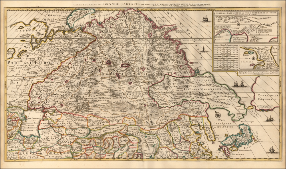
Carte Nouvelle de la Grande Tartarie, par Monsieur N: Witsen, Bourgemaistre. &c. &c. . . .1698
An attractive and detailed 2 sheet map of Tartary filling in so much new information of this area which had not be shown before. Due to Witsen's friendship with the Tsar Peter the Great of Russia and his visits to St Petersburg he was able to research and find out in great detail areas of Central Asia across to China and the northern Pacific Coast Line. The map extends from the Caspian Sea in the west and Nova Zemla in the northwest towards northern China, Korea and the islands of Japan in the southeast of the map. It was one of the most detailed regional maps to date.
The title emphasizes the area known as Grand Tartarie, or Great Tartary, a geographic entity referred to by cartographers from the Middle Ages to the early twentieth century. It stretched from the Caspian Sea and the Ural Mountains all the way east to the northern Pacific Ocean. The region was often split further into more local designations, as this map shows with Tartares Circasses and Tartarie Oreintaux.
Local towns and settlements are marked throughout the map with circles or small building symbols. Additionally, the area’s impressive geographic features are evident, especially the many mountains of the northeast, the forests of the north, and the deserts in southeast Grand Tartarie.
Korea is shown as a peninsula, while Japan is depicted as horizontal, a convention common to early modern maps. Interestingly, north of Japan is Terre de Jedso, connected as a peninsula to Tartarie Orientaux. Historically, Jedso (Eso, Yedso, Yesso) refers to the island of Hokkaido. It varies on maps from a small island to a near-continent sized mass that stretches from Asia to Alaska, but the peninsula form shown here is a rare construction of the feature.
Nicolaas Witsen, a specialist on Russia and its cartography
The map’s title explains that Nicolas Sanson set the map to degrees (although the attribution to Sanson is likely a ruse to get around the French privilege of Alexis Hubert Jaillot of Paris), but attributes the cartography to a Monsieur N. Witsen, Bourgemaistre. This refers to Nicolaas Witsen (1641-1717), a Dutch statesman and mayor of Amsterdam from 1682 to 1706. He was named ambassador extraordinary to the English court in 1689, where he became a Fellow of the Royal Society. He was also administrator to the Dutch East India Company (VOC) from 1693.
As his occupations suggest, Witsen was keenly interested in maritime affairs and he practiced cartography as part of his larger studies. He was also an expert in Russian affairs, having traveled there in the 1670s, which explains how he had the skill and knowledge to compile this map and others. In 1690, he published the first map of Siberia—a south-oriented map, as many Russian maps were at that time. Two years later, he produced a book called Noord en Oost Tartarye to accompany an earlier version of this map, first published in the late 1680s. After the privilege expired, it was reissued by Mortier.
References:
Item Code:
attachment:
