


Artist / Author / Cartographer:
Title:
Date:
Medium:
Size:
Description:
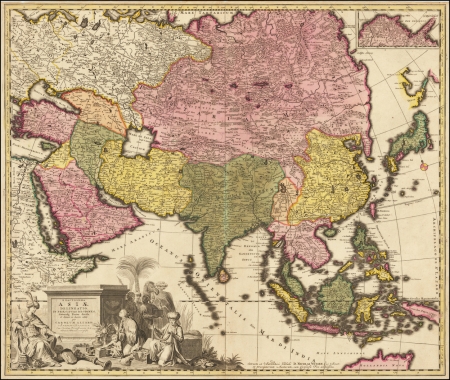
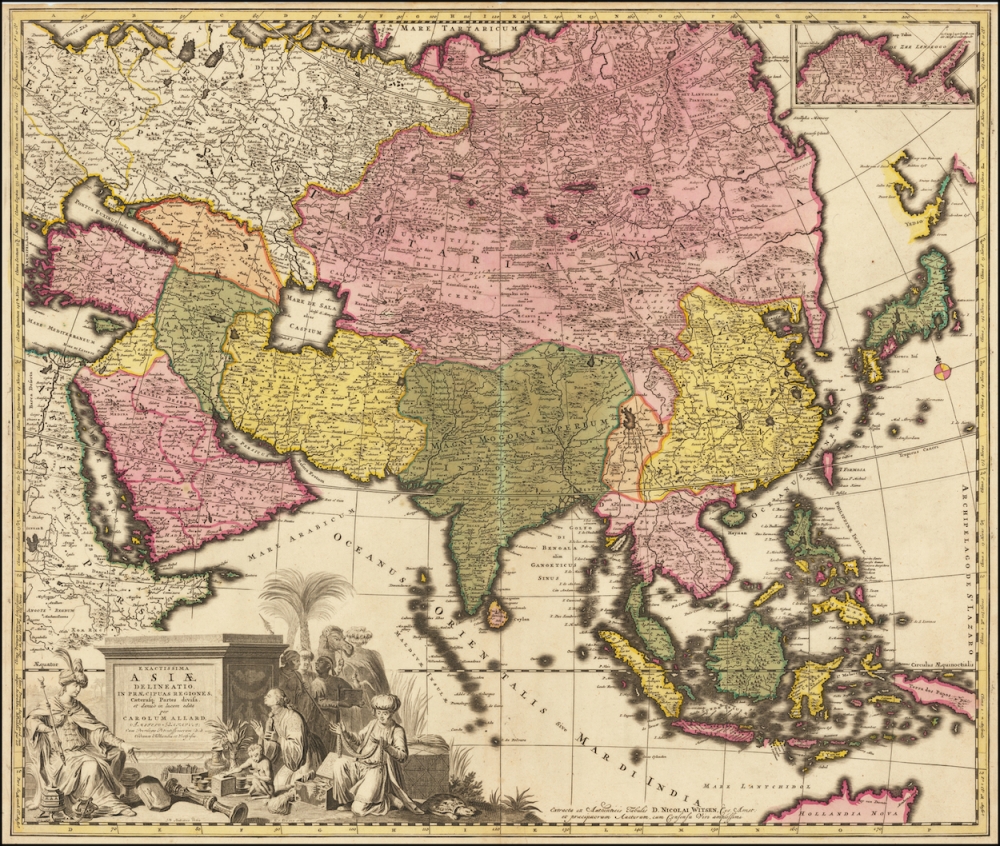
Fine, old-color example of Carol Allard’s map of “exact Asia, delineated into its principal regions,” published in Amsterdam in 1695.
This map marked a substantial step forward in the mapping of Asia, especially in the northeast are previously labeled as Tartary. It was published as part of a series of continental maps, which included sheets showing Africa, America and Europe.
Showing all of continental and insular Asia and including parts of Europe, Africa, and Australia, which is labelled “Hollandia Nova.” The map is tightly framed around the landmasses, with Japan hugging the eastern edge of the map. North of Japan are a series of islands. These include Yedso, a misunderstood exaggeration of Hokkaido common on maps of this period, and Compagnies and Staten Islands, two islands that were sighted by the Dutchman de Vries on his 1643 voyage to find fantastical new lands in the North Pacific.
An inset in the top left-hand corner of the map portrays the furthest northwest protrusion of the Asian continent into the Arctic Sea, which is cut off of the main map by the upper margin. A peninsula with no defined end is labeled “Ys Caep’t uyn Eyndt van dit Hooft is onbekendt” or “Ice cap, the head of which is unknown.” This text, which is unique on a map that otherwise only has place names, seems to indicate what Allard thought was a Northeast Passage from Europe to Asia. Such a possibility fascinated many seventeenth-century Europeans, but it proved elusive and not navigable until centuries later.
When compared to the map of Asia published by Carol Allard’s father, Hugo, c.1660, the most striking difference is the improved mapping of Northeast and Central Asia, labelled “Tartaria Magna.” Allard the Younger drew this vast region, which corresponds to much of modern Central Asia and Siberia, with a nearly unprecedented level of detail and accuracy. He acknowledges the source of this pioneering cartographic information at the bottom of the map: “extracta ex Authenticis Tabulis D. Nicolai Witsen.”
Nicolaas Witsen (1641-1717) was a Dutch statesman, mayor of Amsterdam, administrator of the VOC, and Fellow of the Royal Society. He was also a Russia expert and a sometime cartographer who was the first Western European to describe Siberia in his study Noord en Oost Tartarye. This work was in turn based on rigorous research and correspondence with the author’s contacts in Russia.
Allard’s mapping of Tartary relies on Witsen’s 1687 six-sheet map. Given this fact, it interesting to note that the Qing Empire, which was ruled by Manchu Emperors from Tartary at the time of the map’s publishing is not shown on the map. Allard reproduced the old Ming borders shown in his father’s c.1660 map.
Witsen’s six-sheet map of Tartary, on which this map so heavily relies, became the standard model for the mapping of the region until the expeditions of Bering (1724-1749). For the rest of Continental Asia, Allard draws on De Wit’s maps of Asia, except that he presents a completely different configuration of the Black and Caspian Seas.
For its artistry, accuracy, attention to detail, and pioneering representation of continental Asia, this map is one of the finest examples of its age.
Framed
References:
Item Code:
attachment:
